LiveJTWC warning 6Fri Oct 16, 7 AM ChSTWestern PacificSource: JTWC · NWS Guam

Tropical Storm ChampiLive tracker · Guam typhoon watch · Cat 2 forecast

Strengthening · could reach Cat 4No jokes: follow NWS Guam

Champi is getting stronger and the JTWC takes it to super typhoon · 150 mph. Right now: 46 mph, 796 miles east of Andersen AFB (JTWC). Guam: typhoon watch from the NWS. Closest pass to Guam: 12 mi around Sun Oct 18, 9 AM ChST. Next JTWC warning: Fri 1 PM ChST.

Click the map to zoom with your mouse
TDTS12345ForecastPast34-kt danger swathTY warningTY watchTS warningTS watch
The next five daysTop sustained wind (mph, 1-minute) at each JTWC forecast point · times in ChST (Guam) · dashed lines = thresholds
TS 39TY · CAT 1 74CAT 2 96CAT 3 111CAT 4 130CAT 5 15746NOW4 AM58FRI4 PM69SAT4 AM86SAT4 PM104SUN4 AM121SUN4 PM138MON4 AM150PEAKTUE4 AM144WED4 AM

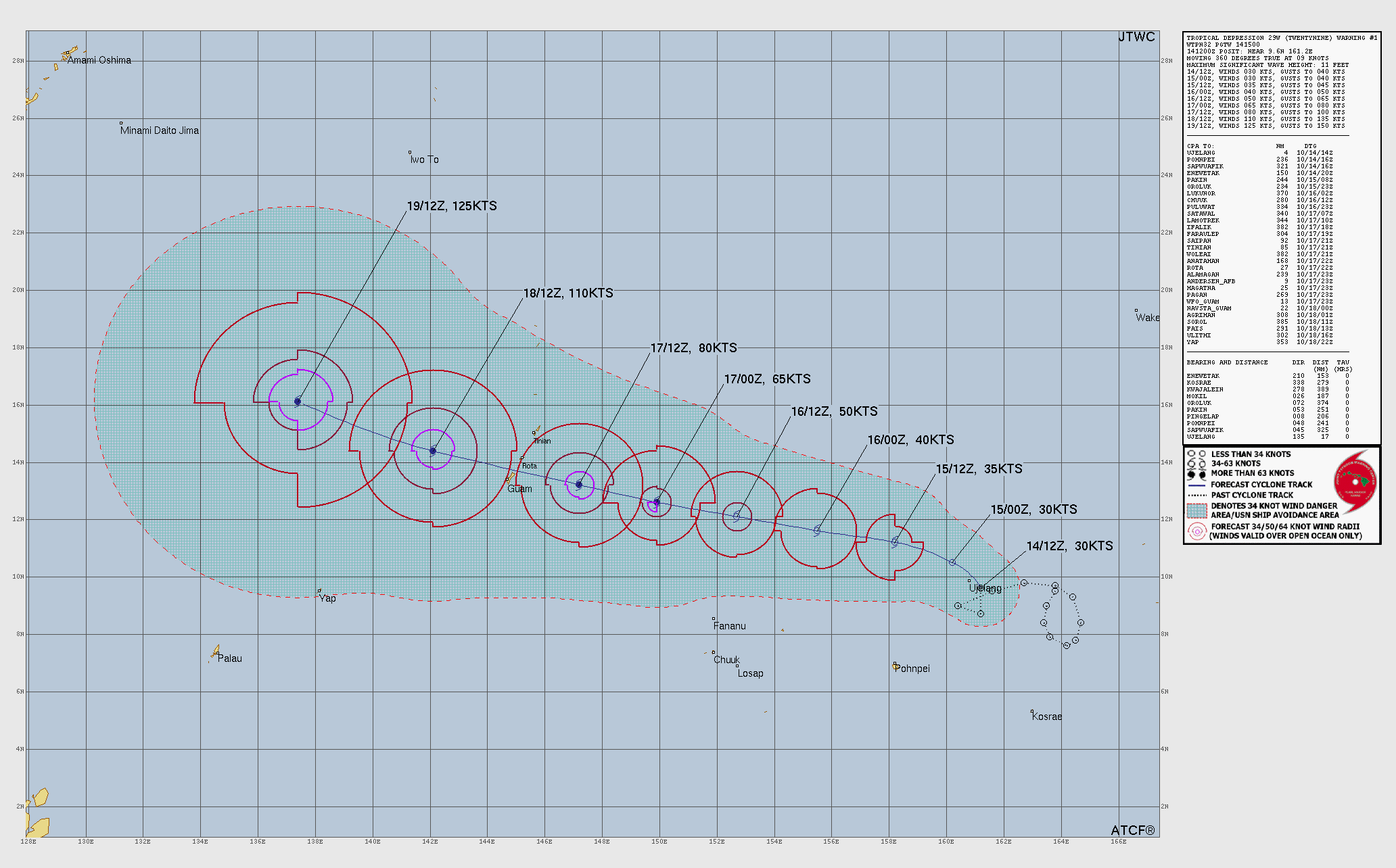
Track, intensity and danger swath: JTWC warning 6 (29W). The JTWC does not issue a cone of uncertainty; the white dashed area is its 34-knot danger swath. Island outlines take the color of their NWS Guam alert. Times are Chamorro Standard Time (ChST, UTC+10).

Guam & the Marianas

NWS Tiyan alerts by island, in Guam time, with the closest pass of the JTWC forecast and the official wind radii at that point.

143°E144°E145°E146°E147°E13°N14°N15°N16°NSun 4 AM · 104 mphSun 4 PM · 121 mphGuamSun 9 AM · 12 miRotaSun 8 AM · 41 miTinianSun 7 AM · 104 miSaipanSun 6 AM · 119 mi
Marianas close-up: JTWC forecast point nearest Guam (Sun Oct 18, 4 AM ChST) with its official 34, 50 and 64-kt wind radii.64 kt+ (typhoon force)50 kt+34 kt+ (tropical-storm force)Island outline = NWS alert color · label = closest pass (our math)

Guam

Typhoon Watch
  • Typhoon Watchno end time set by the NWS
  • Flood Watchuntil Sun Oct 18, 4 PM ChST
  • Hydrologic Outlookno end time set by the NWS

Now: About 800 miles east of Guam (NWS)

Closest pass: 12 mi (20 km), around Sun Oct 18, 9 AM ChST. JTWC point at that time: typhoon, 104 mph (167 km/h) (Cat 2 equivalent); inside the forecast tropical-storm-force (34 kt) wind radius.

Rota

Typhoon Watch
  • Typhoon Watchno end time set by the NWS
  • Flood Watchuntil Sun Oct 18, 4 PM ChST
  • Hydrologic Outlookno end time set by the NWS

Now: About 780 miles east-southeast of Rota (NWS)

Closest pass: 41 mi (67 km), around Sun Oct 18, 8 AM ChST. JTWC point at that time: typhoon, 104 mph (167 km/h) (Cat 2 equivalent); inside the forecast tropical-storm-force (34 kt) wind radius.

Tinian

Typhoon Watch
  • Typhoon Watchno end time set by the NWS
  • Flood Watchuntil Sun Oct 18, 4 PM ChST
  • Hydrologic Outlookno end time set by the NWS

Now: About 765 miles east-southeast of Tinian (NWS)

Closest pass: 104 mi (167 km), around Sun Oct 18, 7 AM ChST. JTWC point at that time: typhoon, 104 mph (167 km/h) (Cat 2 equivalent); inside the forecast tropical-storm-force (34 kt) wind radius.

Saipan

Typhoon Watch
  • Typhoon Watchno end time set by the NWS
  • Flood Watchuntil Sun Oct 18, 4 PM ChST
  • Hydrologic Outlookno end time set by the NWS

Now: About 765 miles east-southeast of Saipan (NWS)

Closest pass: 119 mi (192 km), around Sun Oct 18, 6 AM ChST. JTWC point at that time: typhoon, 104 mph (167 km/h) (Cat 2 equivalent); inside the forecast tropical-storm-force (34 kt) wind radius.

Also from NWS Guam: Chuuk: Small Craft Advisory, Special Weather Statement; Kosrae: Special Weather Statement; Pohnpei: Small Craft Advisory, Special Weather Statement.

NWS Guam, word for word

The official U.S. forecasts and warnings for Guam and the Northern Marianas come from the National Weather Service in Tiyan.

NWS Tiyan public advisory 5A

Issued 512 AM ChST Fri Oct 16 2026. Quoted as issued.

Headline

TROPICAL STORM CHAMPI MOVING WEST TOWARDS THE MARIANAS

Changes

Flood watch is now in effect for Guam, Rota, Tinian, Saipan.

Watches and warnings

A Typhoon Watch remains in effect for Guam, Rota, Tinian and Saipan in the Mariana Islands, and the adjacent coastal waters. A Typhoon Watch means that typhoon conditions, including winds of 74 mph or more, are possible within 48 hours.

A Flood watch is now in effect for Guam, Rota, Tinian, Saipan. A flood watch means excessive runoff may resulting flooding of rivers creeks streams and other low-laying flood-prone locations.

Discussion and outlook

At 400 AM CHST...1800 UTC...the center of Tropical Storm Champi was located near Latitude 11.6 degrees North and Longitude 156.5 degrees East. Champi is moving west at 12 mph. It is expected to maintain this general course towards the Marianas with a slight increase in forward speed through Saturday.

Maximum sustained winds remain at 40 mph. Champi is forecast to continue to intensify.

Next advisory

The next scheduled advisory will be issued by the National Weather Service at 800 AM ChST followed by an intermediate advisory at 1100 AM ChST.

From the NWS Tiyan local statement issued 301 AM ChST Fri Oct 16 2026, quoted as issued.

Wind

AS Tropical Storm Champi (29W) moves closer, the threat for sustained high winds is likely to increase. The latest forecast is for strong tropical storm force winds from early Sunday morning to Sunday afternoon. Typhoon force winds will be possible near the center of Champi mid to late Sunday morning, which could shift a few hours either way.

Surf & inundation

As TD 29W approaches, surf of 3 to 5 feet will begin to increase Saturday. Surf will become hazardous at 7 to 9 feet Saturday evening for at least east facing reefs, then rapidly becoming dangerous and life threatening at 15 to 20 feet Sunday morning. All reefs could be exposed to these dangerous conditions but it is too early to determine which will be affected the most. Depending on the exact location of 29W as it moves through the Marianas, maximum storm surge inundation of 2 to 3 feet is possible, with wave runup as high as 12 feet.

Rain & other effects

Along with winds, dangerous surf and inundation, heavy to torrential rainfall is expected with rain totals amounting to 6 to 12 inches. Therefore, a Flood Watch has been issued.

It is important not to focus on the exact forecast track. To do so could result in bad decisions and place you or those you are responsible for at greater risk. Tropical Storm Champi (29W) is currently moving west towards the Marianas.

Damaging winds are likely within Guam and the Northern Marianas late Saturday night and Sunday. At this time it appears that the strongest winds will be towards the southernmost islands. Islands near the center should prepare for typhoon force winds, with the latest JTWC forecast showing sustained winds of roughly 90 knots.

The story of Champi

Built from the JTWC best track and the latest warning.

a Since then its center has traveled about 1,070 miles (1,722 km).

At JTWC warning 6, Champi is a tropical storm with 46 mph (74 km/h) sustained winds, a central pressure of 999 mb, moving WNW at 12 mph. The JTWC puts the highest significant waves at 15 feet over open water.

The JTWC makes it a typhoon by Sat Oct 17, 4 PM ChST. Its forecast peak is 150 mph (241 km/h) (Cat 4 on the Saffir-Simpson scale), super typhoon strength, around Tue Oct 20, 4 AM ChST. The last forecast point (Wed Oct 21, 4 AM) leaves it about 506 miles from Minamidaito.

Closest approach

Islands and cities within 560 miles of the JTWC forecast track: when the center gets closest and how strong the nearest official point is. Our math, interpolated hourly.

Guam
12mi · 20 km
Sun 9 AMTyphoon
In 34-kt swath
Rota
41mi · 67 km
Sun 8 AMTyphoon
In 34-kt swath
Tinian
104mi · 167 km
Sun 7 AMTyphoon
In 34-kt swath
Saipan
119mi · 192 km
Sun 6 AMTyphoon
In 34-kt swath
Alamagan
283mi · 456 km
Sun 8 AMTyphoon
Outside swath
Pagan
317mi · 511 km
Sun 9 AMTyphoon
Outside swath
Ujelang
320mi · 515 km
NowTropical Storm
Outside swath
Chuuk
328mi · 527 km
Fri 11 PMTropical Storm
Outside swath
Pohnpei
335mi · 539 km
NowTropical Storm
Outside swath
Agrihan
360mi · 580 km
Sun 10 AMTyphoon
Outside swath

In the JTWC’s words

From the prognostic reasoning for warning 6, quoted as issued (all caps, meant for meteorologists).

Significant forecast changes. THE INTENSITY FORECAST HAS BEEN ADJUSTED UPWARD BY 5-10 KTS FROM TAU 12 TO TAU 72.

Forecast discussion. TS 29W IS MOVING WEST TO WEST-NORTHWESTWARD ALONG THE SOUTHERN PERIPHERY OF THE STR. THIS RIDGE WILL ERODE FROM TAU 24 TO TAU 48 AS A TROUGH PASSES WELL TO THE NORTH. MEANWHILE, A SHARP MID-LEVEL TROUGH APPROACHING THE KOREAN PENINSULA WILL SUPPORT THE DEVELOPMENT OF A NEW STR OVER HONSHU. THIS RIDGE WILL SETTLE EAST OF HONSHU NEAR TAU 72 AND BECOME THE PRIMARY STEERING MECHANISM FOR TS 29W, MAINTAINING A WEST-NORTHWESTWARD TRAJECTORY THROUGH TAU 120. THE RECENT EXPLOSIVE CONVECTION AND ONGOING VORTEX CONSOLIDATION MAY FORESHADOW SIGNIFICANT INTENSIFICATION ONCE AXISYMMETRIZATION IS ACHIEVED. VWS WILL EASE TOWARD TAU 60, WHILE TS 29W TRAVERSES VERY WARM SST OF 29-30 DEGREES CELSIUS. THE FORECAST CALLS FOR THE SYSTEM TO BECOME SUFFICIENTLY ORGANIZED TO BEGIN RAPID INTENSIFICATION (RI) NEAR TAU 36, REACHING TYPHOON STRENGTH SHORTLY THEREAFTER AND PEAKING AT 125 KTS AT TAU 96. ALTHOUGH THE ENVIRONMENT BECOMES EVEN MORE FAVORABLE AFTER TAU 72, CHARACTERIZED BY WARMER SST, HIGHER OHC, AND 5-10 KTS OF VWS, THE FORECAST CONSERVATIVELY LEVELS OFF THE INTENSITY AFTER TAU 96 TO ACCOUNT FOR DIFFICULT-TO-PREDICT FLUCTUATIONS IN INTENSITY CAUSED BY INTERNAL TROPICAL CYCLONE DYNAMICS.

Model discussion. THE OVERALL TRACK GUIDANCE REMAINS TIGHT BUT HAS SHIFTED SOUTHWARD ONCE AGAIN. THE BULK OF THE DYNAMICAL AIDS LIES ON THE POLEWARD SIDE OF THE GUIDANCE ENVELOPE, WHILE THE AI MODELS LEAN TOWARD A MORE WESTWARD TRAJECTORY. GOOGLE DEEPMIND HAS ALSO SHIFTED SOUTHWARD AND NOW TAKES THE SYSTEM 30 NM SOUTH OF GUAM. THE MULTI-MODEL CONSENSUS (CONW) AND ECMWF ARE AIMED AT CENTRAL TO NORTHERN GUAM, WHILE GFS AND NAVGEM TARGET THE CHANNEL BETWEEN ROTA AND GUAM. THE AI-MODEL MEAN CLIPS THE SOUTHERN TIP OF GUAM. NEARLY ALL MODELS TRACK THE SYSTEM SOUTH OF ROTA, WITH THE CROSS-TRACK SPREAD AMONG THE RELIABLE AIDS NEAR THE CPA TO GUAM MEASURING 70 NM. THE JTWC FORECAST TRACK IS VERY SIMILAR TO THE PREVIOUS FORECAST, POSITIONED BETWEEN CONW AND THE AI-MODEL MEAN BUT HEDGED CLOSER TO THE AI-MODEL MEAN. IF CURRENT TRENDS CONTINUE, SUBSEQUENT FORECASTS MAY NEED TO SHIFT THE TRACK FARTHER SOUTH. THE INTENSITY AIDS HAVE TRENDED STRONGER THIS CYCLE. DEEPMIND NOW DEPICTS VERY AGGRESSIVE INTENSIFICATION, BRINGING TS 29W TO 115-130 KTS BY TAU 60. HAFS-A AND GFS ARE SLOWER TO INTENSIFY THE SYSTEM FOR THE FIRST 60 HOURS. HOWEVER, HAFS-A EVENTUALLY STRENGTHENS TS 29W TO 155 KTS AT THE END OF THE FORECAST PERIOD. THE COAMPS-TC AND DEEPMIND ENSEMBLES PEG THE RI PROBABILITY NEAR 80 PERCENT, WITH 75-85 PERCENT OF THE MEMBERS ACHIEVING SUPER TYPHOON INTENSITY BY TAU 96. THE JTWC INTENSITY FORECAST HAS BEEN INCREASED BY 5-10 KTS FROM TAU 12 THROUGH TAU 72, WHILE THE TAU 96 AND TAU 120 FORECAST INTENSITIES REMAIN UNCHANGED. THE FORECAST LIES NEAR THE CENTER OF THE GUIDANCE ENVELOPE THROUGH TAU 48, THEN TRENDS TOWARD THE UPPER END OF THE ENVELOPE BY TAU 96 AND TAU 120. IF TS 29W CONTINUES TO CONSOLIDATE AT THE CURRENT RATE, SUBSEQUENT INTENSITY FORECASTS MAY NEED TO BE FURTHER INCREASED.

Forecast confidence. TRACK 00-72 HR: HIGH · TRACK 72-120 HR: HIGH · INTENSITY 00-72 HR: MEDIUM · INTENSITY 72-120 HR: MEDIUM


Intensity

Champi’s 1-minute sustained wind from the JTWC best track (white) and its forecast (dashed), on the Saffir-Simpson bands.

Quick questions

Where is Tropical Storm Champi now?

At JTWC warning 6 (Fri Oct 16, 4 AM ChST) the center of Champi was near 11.5°N 156.5°E, with 46 mph (74 km/h) sustained winds. NWS Guam advisory 5A put it “About 800 miles east of Guam.”

Will Champi hit Guam?

Guam is under a Typhoon Watch from the National Weather Service in Tiyan. On the JTWC forecast the center passes about 12 miles (20 km) from Guam around Sun Oct 18, 9 AM ChST, and the official point nearest that time is a typhoon with 104 mph (167 km/h), Cat 2 equivalent. Follow Guam Homeland Security / Office of Civil Defense and CNMI Homeland Security and Emergency Management for shelters and orders.

When will Champi's winds reach Guam and the Marianas?

The NWS Guam local statement (301 AM ChST Fri Oct 16 2026) says: “AS Tropical Storm Champi (29W) moves closer, the threat for sustained high winds is likely to increase. The latest forecast is for strong tropical storm force winds from early Sunday morning to Sunday afternoon. Typhoon force winds will be possible near the center of Champi mid to late Sunday morning, which could shift a few hours either way.”

How strong will Champi get?

The JTWC forecast peaks at 150 mph (241 km/h) (Cat 4 on the Saffir-Simpson scale) around Tue Oct 20, 4 AM ChST. The JTWC calls a storm a typhoon from 64 knots (74 mph) and a super typhoon from 130 knots (150 mph); its winds are 1-minute sustained, like the NHC's.

Why is there no cone of uncertainty?

The JTWC does not publish a cone like the NHC's. The map shows its “34 knot Danger Swath” instead: the band its official Google Earth layer marks as possibly swept by 34-knot or stronger winds along the forecast. The colored line is the JTWC forecast track.

When is the next Champi update?

The JTWC issues warnings every six hours; the next ones are due Fri 1 PM, Fri 7 PM, Sat 1 AM (ChST). NWS Guam: “The next scheduled advisory will be issued by the National Weather Service at 800 AM ChST followed by an intermediate advisory at 1100 AM ChST.” We check both sources every 30 minutes.

Straight from the source

JTWC products are U.S. government works (public domain). The JTWC says its products are intended for U.S. government agencies; for official warnings in Guam and the Northern Marianas, follow the National Weather Service in Tiyan and local emergency officials.